Geological exploration in the South Coastal (Yuzhno-Pribrezhnoye)
deposit of the Saratov region.
The goal of the project is to conduct oil and gas exploration at the South Coastal field to clarify the geological structure of the tula deposit, the position of the oil-water complex, the thickness and nature of the distribution of reservoirs, lithological dissection of the section, determination of the reservoir replacement areas, refinement of production capabilities and the construction of a technological scheme of development of the field.
The South Coastal field is located in the Rovensky district of the Saratov region.
This region produces 1.8% of all oil produced in the Volga region, 17% of natural gas.
Potential oil resources in the region amount to about 700 million tons. The area of the South Coastal license is 12 square km. The boundaries of the subsoil plot are limited by a contour with the following geographical coordinates of its corner points:
1) 50° 52′ 39″ N | 46° 08′ 09″ E
2) 50° 52′ 39″ N | 46° 11′ 31″ E
3) 50° 51′ 00″ N | 46° 11′ 31″ E
4) 50° 51′ 00″ N | 46° 08′ 09″ E
During the test in the cased column, oil and dissolved gas were obtained from reservoirs confined to the tula horizon.
Stratigraphically, the South Coastal field belongs to the visean oil and gas complex of the tula reservoir. According to the complexity of the geological structure, the occurrence conditions and sustainability of the productive tula reservoir beds, the South Coastal field is a simple one. The wells drilled in the field opened a sedimentary cover composed of Cenozoic, Mesozoic and Paleozoic sediments.
In the South Coastal field, during the well testing, two productive strata were discovered in the tula reservoir: I – upper terrigenous reservoir and II – lower carbonate reservoir. The oil-bearing area of the Coastal field in category C1 in the C1 bb reservoir was -780 thousand square m. According to preliminary data, the recoverable reserves of the field amount to 122 thousand tons of oil and 18 million cubic meters of dissolved gas.
The stages of the implementation of the program of exploration for oil and gas in the South Coastal field:
1. Implementation of seismic exploration works for MOGT 3D and MSC on the South Coastal area in order to prepare for the production of exploratory drilling and the start of development. The scope of work is at least 12 square km.
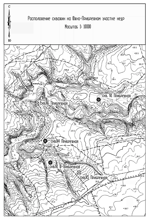
2. Collection of field geophysical materials (GIS) for the fund of previously drilled prospecting and exploration wells in the subsoil section (number 1, 4, 5 and 6 Coastal), digitization and modern interpretation of the primary material for correlation over the area of the area identified by well number 1 U. The coastal oil-saturated formations of tula age and the study of new reservoir formations in the middle and lower coal complex of rocks (C2 cm-pk; C1S-ok; C 1bb; C1 kz-cr; C 1up; C 1ml).
3. Using the existing stock of wells. To speed up the preparation of an open South-Coastal field for development during the early stage of exploration, use the existing well stock (number 1 U. Coastal and number 4 Coastal) to study in detail the mining capabilities of tula reservoirs in various modes, to study physical and chemical properties of reservoir fluids, changes in time values of reservoir pressure in two stages:
I – Development of the project of trial operation of wells 1 and 4;
II – Trial operation and exploration of wells 1 and 4.
4. Establishment of an exploration well number 10. Implementation of a project for the exploration of oil and gas deposits in the South Coastal field. On the basis of updated structural maps for the tula horizon, proceed to the implementation of a project for the exploration of oil and gas deposits in the South Coastal field. The project should include
the laying of one exploration well number 10 with a design depth of 3250 m.
5. Conducting exploratory drilling of well number 10 of the South Coastal field. As an associated task, the study of new reservoirs in the middle and lower coal complex of rocks (C2 cm-pk; C1S-ok; C 1bb; C1kz-cr; C 1up; C 1ml) is provided for their regional productivity using ISTOD method.
6. Estimation of the oil-bearing area of open deposits. According to the results of exploratory drilling and research work carried out and test operation of open deposits in the wells number 1, number 10 of the South Coastal and number 4 Coastal to assess the area of oil content of open deposits, the thickness of oil-saturated reservoirs, the FES reservoir beds; to clarify the flow rates of oil, to establish reservoir pressure, to clarify the position of VNC, to study reservoir fluids.
7. Estimation of reserves of oil and gas dissolved in oil of the tula deposit in the South Coastal field on the basis of the material obtained. The possibility of including newly discovered deposits in the C1 and C2 categories in the new reservoirs in the middle and lower coal complex of the rocks (C2 cm-pk; C1S-ok; C 1bb; C1kz-cr; C 1up; C1kz-cr;
C 1up; C 1ml) due to their regional productivity.
8. Preparation and submission of the technological scheme for the development of the field on the results of exploration work for Rosnedra TsKR.